PNM 20230726
- Thomas Breckel

- Jul 25, 2023
- 4 min read
Updated: Jul 26, 2023
PREPARE NOW MESSAGE (PNM 20230726)
Issued: 25 July 2023
Impact Weather: Wednesday (26 July 2023)
UPDATE #4 (2:24 pm on Wednesday, 26 July 2023)
Summary of changes:
Nothing Significant To Report for Clinton County.
Concerns still center on the potential for severe weather, however, severity and confidence decreases along and south of I-70. HEAT ADVISORY in effect for Clinton Co. from Noon on Thursday (27 July) thru 9 pm on Friday (28 July).
[END]
- - - - - - - - - - - - - -
UPDATE #3 (7:30 am on Wednesday, 26 July 2023)
Summary of changes:
Threat to Clinton County has been downgraded.
Primary threats are mainly north of I-70.
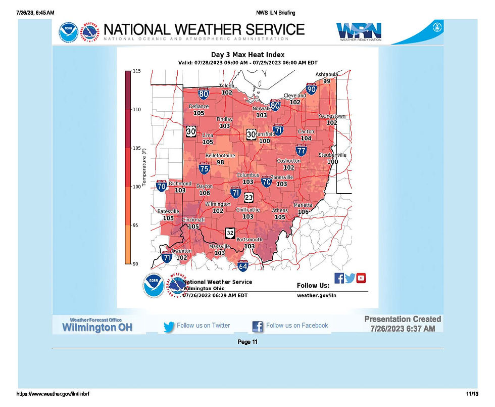
Significant risk for extreme heat (HEAT ADVISORY in effect for Clinton Co. from Noon on Thursday (27 July) thru 9 pm on Friday (28 July).
Updated NWS messaging:
Any scattered storms this morning into early afternoon are expected to remain sub-severe.
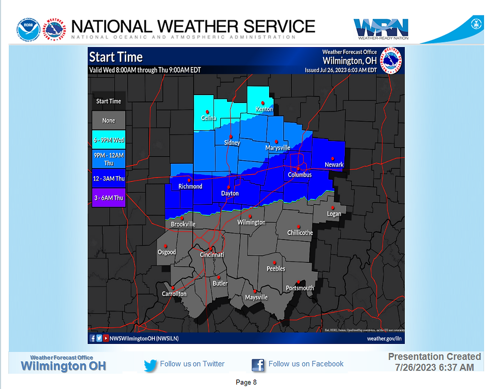
Additional thunderstorms will move through the area late Wednesday afternoon into the early overnight. The primary window for severe storms is from 6 PM Wednesday to 1 AM Thursday.
Damaging winds and large hail will be the primary threats with these storms.
An isolated tornado cannot be ruled out, especially across northern Ohio.
Confidence in storms is medium and timing is medium. Confidence in storm severity decreases along and south of I-70.
A few instances of flash flooding are possible across northern Ohio where storms with torrential rainfall rates repeatedly move over the same areas.
Outlook: Heat and humidity will build into the region Thursday and Friday. The heat and humidity will linger across southern areas into Saturday.
Updated slides:


Still looking HOT on Thursday.

Really looking HOT on Friday.

Still HOT'ish on Saturday.

[END]
- - - - - - - - - - - - - -
UPDATE #2 (6:30 am on Wednesday, 26 July 2023)
Summary of changes:
Threat to Clinton County has been downgraded.
Primary threats are mainly north of I-70.


Thursday (HOT).

Friday (HOTTER).

Saturday (LESS HOT).

[END]
- - - - - - - - - - - - - -
Update #1 (2:30 pm on Tuesday, 25 July 2023).
Summary of changes:
Updated text/graphics
Time of arrival graphic added
Heat concerns for Thursday - Saturday added
NWS messaging:
There will be a chance of Wednesday morning/ Wednesday early afternoon thunderstorms. These storms are expected to remain sub-severe.
Additional thunderstorms will move through the area late Wednesday afternoon into Wednesday night. The primary window for severe storms is from 6 PM Wednesday to 3 AM Thursday.
Damaging winds and large hail will be the primary threats with these storms. An isolated tornado cannot be ruled out, especially across northern Ohio.
Confidence in storms is medium and timing is medium. Confidence in severity decreases along and south of I-70.
Outlook: Heat and humidity will build into the region Thursday and Friday. The heat and humidity will linger across southern areas into Saturday.
Updated NWS Wx briefing slides:


Next update on Wednesday morning, 26 July 2023.
[END]
- - - - - - - - - - - - - -
Original posting (8:30 am on Tuesday, 25 July 2023).
NWS messaging:
Thunderstorms will move through the area Wednesday afternoon into Wednesday night. The primary window for severe storms is from 3 pm to midnight.
Damaging winds and large hail will be the primary threats with these storms. An isolated tornado cannot be ruled out, especially across northwest Ohio.
Confidence in storms is moderate and timing confidence is moderate.
Damaging Winds: Elevated Risk.
Hail (area wide): Elevated Risk.
Tornado (Northwest Ohio): Limited.
Notice: Information regarding issue with automated emergency alerts with Rave Mobility for Clinton County Emergency Alerts (CCEA). https://www.cc-ema.org/post/ccea-notice
Storms on Wednesday and heat on Thursday/Friday:

NWS Weather Brief (updated slides maintained here --> https://www.weather.gov/iln/ilnbrf)


(Static radar image as of this brief. The link above will provide an active page for the viewer.)


NWS weather graph data as of 6 am on Tuesday (25 July) for Wednesday (26 July):

Recommended Actions:
Review actions and begin implementing as they apply to your situation. Use keywords SEVERE, TORNADO and POWER at https://www.cc-ema.org/prepare
If you have a member of your household that has serious medical conditions and require an electrically powered medical device? Then you may want to look into the following programs from our area providers.
AES Program: https://www.aes-ohio.com/outages (look under the Power outage FAQs questions for "I have special medical condition and rely on electricity to keep medical equipment running..."
Duke Energy: https://www.duke-energy.com/.../special.../life-suppor
The Emergency Notices Page is not active as of this post, but if the situation continues to deteriorate, you can check for information on What to Do, What NOT to DO, Where to Go, Where to Avoid, and additional information.
If you have not signed up for Emergency Alerts (if you did not receive a text with the link to this post, you are not signed up), you may want to sign up using one of two different methods.
Option #1 (see phone image) is to text to opt-in for all county level alerts.
Option #2 is to create an account with alerts that just impact the address you provide. You can provide up to 15 addresses (e.g. home, work, school, rental properties, parents, kids, et cetera). Each address has to be located within Clinton County.
Event Organizers: If you are holding an event over this period and are interested in receiving Weather Observation messages (text or email via DTN Wx Sentry) to support your decision making for any outdoor related activities for the areas listed below, please contact EMA.
Send email to breckel.thomas@clintoncountyohio.us with your org name, individual name(s), email, and mobile number to be added (no cost). Please specify if there are desired quiet times to not receive observation alerts. You will need to specify which areas below you want coverage for.
Blanchester
Clarksville
Lees Creek
New Vienna
Port William
Sabina
Wilmington
Stay Weather Aware this week!
[END]
- - - - - - - - - - - - - -
PNM - Prepare Now Message for events with forecasted high severity or impact (e.g. tornado potential, power outage potential, et cetera).
SWA - Stay Weather Aware message for events with the potential of some local impacts (e.g. localized power outage potential, et cetera).
HUM - Heads Up Message for events that are too far off for certainty, but may become significant local threats. Intent is to provide advanced heads up for those with household issues to begin preparing for the potential of impact (e.g. medical, livestock, et cetera).


Comments