

Thursday 20260326
- Thomas Breckel

- Mar 25
- 6 min read
Updated: Mar 26
Storms Possible Late Thursday Night in Clinton County
Update No. 2
Posted: 6:15 am on Thursday, 26 March
NWS Briefing Click here
SUMMARY: Thunderstorms capable of damaging winds will move into Clinton County late tonight, generally between 11 PM and 1 AM, with all of the county under a SLIGHT Risk for severe weather (except Klocks Corner and West Lynchburg area in the county heel we remain in a MARGINAL Risk).
Primary Threats
Damaging Winds - Strong wind gusts remain the primary severe weather threat tonight. Possible impacts may include:
Downed trees
Isolated power outages
Minor structural damage
Large Hail - Some storms may produce hail capable of minor damage to vehicles or outdoor objects.
Isolated Tornado - While the tornado threat is 🤏 lower for Clinton County than areas farther north, an isolated tornado cannot be ruled out with stronger storms.
Rainfall and Flooding - The Weather Prediction Center places southwest Ohio in a 5% risk area for excessive rainfall tonight, meaning isolated or localized flooding may occur. Possible impacts include:
Water over low-lying roads
Ponding in poor drainage areas
Brief localized flash flooding
Rainfall impacts will depend on where heavier storm cells develop and track.

Key Takeaways
Storms most likely arrive 11 PM – 1 AM tonight
Damaging winds remain the primary threat
All of Clinton County is now within the SLIGHT risk area except the heel of the county near Klocks Crossing and West Lynchburg
Localized flooding is possible due to heavy rainfall in stronger storms
Storm intensity is expected to gradually decrease as storms move south

Storms are expected to develop across Indiana and western Ohio this evening and move southeast overnight. As these storms move south toward Clinton County, they may gradually weaken but still have the potential to produce severe weather impacts.
The National Weather Service briefing also indicates the start time of thunderstorms has been moved slightly earlier compared to the previous forecast.
Additional information: For those who closely monitor tornado potential—even when the overall risk is low—the Nadocast Significant Tornado Parameter currently highlights the more favorable environment north of Interstate 70, indicating that the primary area of concern remains well north of Clinton County.

But wait, there's more! Additional information for those that say Hmmmm 🤔
Weather Nerd Nugget: Nadocast Tornado Signals to Watch 👀
For my fellow weather nerds who like to go a layer deeper than the outlooks…
NADOCast

Scroll down to the current year/month folder (format: YYYYMM).
Select the current date.
Choose the latest model run (labeled t#z).
Browse the graphics and select the parameter you want to view.
For easiest viewing, open the .png files.
The graphic I usually focus on is stp (Significant Tornado Parameter), since it combines several tornado ingredients into a single indicator.
HRRR Model (Pivotal Weather)

From the top menu, select MODELS.
Choose HRRR.
On the left menu, scroll down and expand SEVERE WEATHER.
Select SIGNIFICANT TORNADO PARAMETER (SigTor).
Now select a Forecast Hour from the upper-left menu.
Important notes:
Times are shown in UTC (London time).
To convert to Eastern Time, subtract 4 hours.
The display uses a 24-hour clock.
Example:
If you select forecast hour 010, it may display:
Thu 2026-03-26 19Z
That means:
19Z = 1900 UTC
1900 − 4 hours = 1500
3:00 PM Eastern Time
You can then step through the forecast hours (typically in 3-hour increments) to see when the environment may become most supportive for severe weather.
Still confused? Sometimes it’s easier to look at a simple line graph visualization, (click
here) where the red line highlights increasing tornado-supportive conditions.
- - - - END UPDATE No. 2 // BEGIN UPDATE No. 1 - - - -
Update No. 1
Posted: 3 pm on Wednesday, 25 March
NWS Briefing Click here

Summary: Most of Clinton County is now in a Slight Risk (2 out of 5) for severe weather, with storms expected mainly between about 1 AM and 3 AM Friday morning, and damaging winds remaining the primary threat.
Main Threats:
Damaging wind gusts
Large hail
Brief heavy rain in some locations
Very low chance of an isolated tornado
The latest forecast update shows most of Clinton County now in the Slight Risk area for severe weather, while the Klocks Crossing and West Lynchburg areas remain in a Marginal Risk. In the Slight Risk area, there is about a 15% chance for damaging winds and a 15% chance for hail. The tornado risk remains low at around 2%, but it is not zero.

The expected start time for storms in Clinton County has shifted later, with storms now most likely between about 1 AM and 3 AM Friday morning as the line of storms moves south into the area. Damaging winds remain the primary concern, with scattered downed trees or power lines possible if stronger storms develop.
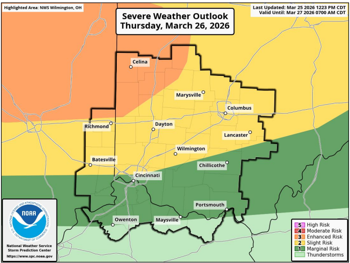
While Clinton County’s risk is lower than areas farther north, the forecast shows the highest severe weather risk generally along and north of Interstate 70, where an Enhanced Risk area is now in place. Anyone traveling north of I-70 Thursday afternoon or evening should be aware that storms in that area could be stronger.
At this time, storms are expected to gradually weaken as they move south overnight, which may reduce the overall severity for southern counties such as Clinton.
Clinton County EMA will continue monitoring the forecast and will provide additional updates if conditions change. Residents are encouraged to have a reliable way to receive weather alerts overnight while they are sleeping.
If you’re heading to Reds Opening Day, expect a damp start to the morning, mostly sunny skies during the game, and storms moving in later during the overnight hours. Honestly, not a bad way to spend a “sick day”… you know, fighting off that sudden cold that mysteriously appeared overnight. ⚾
- - - - END UPDATE No. 1 // BEGIN ORIGINAL POST - - - -
Summary: A few thunderstorms are expected late Thursday night, and while the overall risk is low, a few storms could briefly become strong.

Possible Threats
Strong wind gusts
Large hail
Heavy rain in some locations that could cause brief flooding
Very small chance of a tornado
Timing
Storms may occur between about 8 PM Thursday and 4 AM Friday morning.
The majority of Clinton County is currently in a Marginal Risk (1 out of 5) for severe weather. This means most storms will likely stay below severe levels, but a few could briefly become stronger. Areas near the northwest edge of the county ... including New Burlington, North Kingman, Lumberton, and Port William ... are at a SLIGHT risk (2 out of 5) area where stronger wind gusts are somewhat more possible.
The biggest concern with these storms would be isolated strong wind gusts and

pockets of large hail. Some storms may also produce brief heavy rainfall, which could lead to localized flooding in low-lying areas. While the chance is small, a tornado cannot be completely ruled out.
Storms are expected to arrive later in the evening, which may limit how strong they become because the atmosphere may not have as much energy available. Forecasters will continue to monitor conditions overnight.
At this time, a quick check of short-term severe weather prediction tools such as NADOCast does not show any major areas of concern for Thursday night.
Clinton County EMA will continue to monitor the forecast and will provide updates if
conditions change. Residents are encouraged to make sure they have a way to receive weather alerts overnight.
Note: The weather graph highlights several helpful details to understand the forecast
for Thursday.

The dates are marked in yellow along the timeline so you can easily see when weather changes are expected.
Wind gusts are highlighted in pink, making it simple to spot the periods when stronger winds may occur as storms move through the area.
The black arrows point to key data labels on the graph, helping identify the specific times when precipitation and thunder are most likely.
One piece of good news is that no snow, freezing rain, or sleet is expected on Thursday. Instead, the chart mainly shows periods of rain and thunderstorms, giving a clear visual of when our area may see active weather.


Comments