


20260810 HUM

Updated: Aug 11
UPDATE No. 4
Posted 6:20 am on Tuesday, 11 August 2026
Summary / What Has Changed
The damaging-wind threat has increased for Clinton County. NWS Wilmington raised the wind threat from Elevated to Significant. Numerous downed trees and power lines are now expected across the region, and some structural damage is possible.
The timing is much clearer than it was Monday. The main severe-weather period for Clinton County is now expected from about 3 PM to 9 PM today, with the greatest concern during the late afternoon and evening.
The ENHANCED nced Risk (3 of 5) for severe thunderstorms remains in place for Clinton County. Today remains the most dangerous weather day in this multi-day period.
The flooding threat remains. A Flood Watch is in effect, and repeated thunderstorms may produce flash flooding, especially where heavy rain falls more than once.

Threats — Highest to Lowest
Damaging Wind — PRIMARY THREAT: This is the threat to take most seriously in Clinton County today. Strong storms may produce intense straight-line winds capable of bringing down trees and power lines, causing power outages, blocking roads, and damaging buildings. NWS now has high confidence in damaging straight-line winds with the main afternoon/evening round.
Flash Flooding: Heavy rain may fall several times over the same area. This could quickly flood low spots, poor-drainage areas, roads, small streams and creeks.
Lightning: Any thunderstorm can produce dangerous lightning. If you can hear thunder, you are close enough to be struck.
Tornado: The greater tornado threat is north of Clinton County, mainly north of I-70. Clinton County's risk is much lower, roughly 2% to 4%, but it is not zero. An isolated tornado remains possible, so do not ignore a Tornado Warning if one is issued. The NWS briefing continues to state that an isolated tornado cannot be completely ruled out.
Timing
Morning through early afternoon: Additional thunderstorms are possible. These storms may affect how strong the later storms become and exactly where the greatest threat develops.
3 PM to 9 PM: This is the main period of concern for Clinton County. Damaging straight-line winds are the primary threat. Be ready for warnings and rapidly changing conditions.
Tonight: Heavy rain and flooding may continue after the main severe-weather threat begins to decrease. Multiple rounds of rain remain possible.
Wednesday: Additional thunderstorms remain possible, but the severe-weather threat should be lower than today. Damaging winds and flooding remain possible, and Wednesday's forecast will depend on what happens today.

Additional Notes
Do not focus on the tornado threat and miss the bigger danger. For Clinton County, damaging straight-line wind is the main concern today. Winds from severe thunderstorms can knock down large trees and power lines and damage buildings even when no tornado occurs.
Prepare for power outages before storms arrive. Charge phones and other needed devices, secure outdoor items, and make sure you have more than one way to receive weather warnings.
Stay away from downed power lines and treat every downed line as energized.
Do not drive through flooded roads. Water may be deeper or moving faster than it appears.
Be where you need to be before the 3 PM–9 PM window begins. Do not wait until a warning is issued to decide where you will go.
Clinton County EMA will continue monitoring conditions and will issue additional information as needed. The next NWS Wilmington decision-support briefing is expected by 5 PM today.


Bottom Line for Clinton County
Today is primarily a damaging-wind event for Clinton County. The wind threat has increased, NWS confidence has increased, and the main period of concern is now 3 PM to 9 PM. Flooding remains a concern, and while the greatest tornado threat is north of Clinton County, our tornado risk is low—not zero.
- - - - END UPDATE No. 4 - - - -
UPDATE No. 3
Posted 5 pm on Monday, 10 August 2026
What Changed Overall
The greatest change is for Tuesday, which is now expected to be the most hazardous day of this weather period for Clinton County. The severe-weather threat increased from SLIGHT Risk (2 of 5) to ENHANCED Risk (3 of 5), the flooding threat increased to a Moderate Risk (3 of 4), and a Flood Watch is now in effect through Tuesday night.
The overall types of weather threats have not changed. Damaging winds and heavy rainfall/flash flooding remain the main concerns, with a lower chance for an isolated tornado.
DAY 1 — Monday, August 10, 2026
There has been little change for Clinton County tonight since the previous briefing. One or more rounds of thunderstorms and heavy rainfall remain possible, but there is still considerable uncertainty about exactly when and where the strongest storms will occur.
Damaging winds remain the primary threat. Heavy rainfall and flash flooding are also possible where thunderstorms repeatedly move across the same area, and an isolated tornado cannot be ruled out. The threat continues through tonight.

DAY 2 — Tuesday, August 11, 2026
Tuesday has changed the most since the previous briefing. Clinton County has been increased from a Slight Risk (2 of 5) to an Enhanced Risk (3 of 5) for severe thunderstorms, and the county is now within a Moderate Risk (3 of 4) for excessive rainfall; a Flood Watch is also in effect through Tuesday night.
Intense damaging wind gusts remain the primary severe-weather threat. Flash flooding is now also a significant concern because several rounds of heavy rain may cross the same areas, leading to rapid runoff and rises in streams and creeks; an isolated tornado cannot be ruled out.
NWS Wilmington now has high confidence that severe weather and flash flooding will occur somewhere in the region Tuesday, but there is still low confidence about the exact timing and locations of the greatest impacts. Multiple rounds of thunderstorms are possible throughout Tuesday and into Tuesday night, so there is not one single reliable time window for Clinton County residents to focus on.

DAY 3 — Wednesday, August 12, 2026
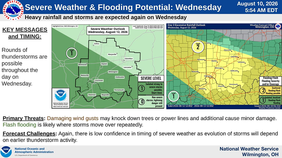
There is no major change to Wednesday's outlook for Clinton County. Additional thunderstorms remain possible, but the severe-weather threat is expected to be lower than Tuesday and will depend heavily on where Tuesday's storms occur.
Heavy rainfall and localized flooding remain important concerns, especially if Clinton County receives significant rainfall Tuesday. Stronger thunderstorms could also produce damaging winds. Thunderstorms may occur throughout Wednesday, but exact timing remains uncertain.
DAY 4 — Thursday, August 13, 2026
There is little change for Thursday. The main concern remains additional heavy rainfall falling on areas that may already be wet from several rounds of storms earlier in the week.
Flooding remains the primary concern for Clinton County, particularly in poor-drainage areas, low spots, small streams and creeks, and locations that receive repeated rainfall. The exact timing of thunderstorms Thursday remains uncertain.
Bottom Line for Clinton County
Tuesday is now clearly the day of greatest concern. Clinton County faces both an Enhanced severe-weather risk and a Moderate excessive-rainfall risk, with intense damaging winds and flash flooding as the main threats.
Residents should be prepared for more than one round of thunderstorms Tuesday, possible power outages, downed trees and power lines, flooded or blocked roads, and rapidly changing conditions. Do not focus on one specific arrival time—the latest NWS briefing says thunderstorms and heavy rainfall may affect the region throughout the day Tuesday and into Tuesday night.
- - - - END UPDATE No. 3 - - - -
UPDATE No. 2
Posted 6:45 am on Monday, 10 August 2026
What changed overall: The forecast for Monday and Tuesday has changed only slightly, while the threat for Wednesday and Thursday is now better defined, especially for heavy rainfall and flooding.
What has not changed: Clinton County remains in an active weather pattern with several chances for strong thunderstorms and flooding through at least Tuesday night, with additional problems possible later in the week.
Because today is Monday, DAY 1 is now Monday, DAY 2 is Tuesday, DAY 3 is Wednesday, and DAY 4 is Thursday.

DAY 1 — Monday, August 10, 2026
Changed: There has been little change to Monday's overall severe-weather outlook, but

the latest NWS briefing now lists the limited tornado threat across the area rather than only north of I-70 in the previous briefing.
Unchanged: Clinton County remains SLIGHT Risk (Level 2 of 5 for severe storms), with several rounds of storms possible today and tonight.
Primary Threat: Damaging winds remain the main concern, with some storms capable of knocking down trees and power lines; the latest SPC outlook also continues to identify damaging wind as the leading threat across the region.
Additional Threats: Heavy rainfall could cause flash flooding where storms repeatedly cross the same area, and an isolated tornado cannot be ruled out; hail is also possible but is a lower concern for Clinton County.
Timing: The main period of concern remains about 3 PM through tonight, although storms this morning could change exactly when and where the strongest storms develop.
DAY 2 — Tuesday, August 11, 2026
Changed: The latest briefing now includes a limited tornado threat for Tuesday

across the area, which was not included in the previous NWS summary.
Unchanged: Clinton County remains SLIGHT Risk (Level 2 of 5 for severe storms), and the Level 2 flooding concern also remains in place.
Primary Threat: Damaging winds remain the main severe-weather threat, and SPC continues to show the Ohio Valley at risk for damaging winds Tuesday.
Additional Threats: Repeated heavy rainfall could produce flash flooding, and there is now a low chance for an isolated tornado.
Timing: Storms may occur from the morning into the middle of the day and again during the evening and overnight, with the greater damaging-wind concern currently expected during the afternoon and evening.
DAY 3 — Wednesday, August 12, 2026
Changed: Wednesday is now better defined, with Clinton County in a MARGINAL Risk

(Level 1 severe-storm risk and a Level 2 flooding risk), while the previous briefing provided much less detail beyond Tuesday.
Unchanged: Wednesday's forecast still depends heavily on what happens Tuesday, and the threat may decrease if Tuesday's storms use much of the energy needed for stronger storms Wednesday.
Primary Threat: Heavy rainfall and flash flooding are the greater concern for Clinton County, especially where several storms move across the same location.
Additional Threats: Isolated strong storms may still produce damaging winds, but the severe-weather threat is lower than Monday and Tuesday.
Timing: Thunderstorms are possible throughout Wednesday, with any stronger wind-producing storms more likely during the late afternoon and early evening.
DAY 4 — Thursday, August 13, 2026
Changed: Thursday has now been added to the detailed outlook, with Clinton County placed in a Level 2 flooding risk because additional heavy rain may fall over areas already affected earlier in the week.
Unchanged: Earlier forecasts already suggested that weather and flooding problems could continue beyond Tuesday, but the Thursday flooding concern is now more clearly identified.
Primary Threat: Heavy rainfall and flash flooding are the main concerns, particularly if Clinton County receives repeated heavy rain Monday through Wednesday.
Additional Threats: Strong thunderstorms may still be possible, but there is not enough confidence yet to identify severe weather as a main Thursday threat.
Timing: The flooding concern continues through Thursday and into Thursday night, but the exact timing of thunderstorms is still uncertain.
Bottom Line for Clinton County
Monday and Tuesday remain the main severe-weather days, with damaging winds the primary threat. Wednesday and Thursday now deserve more attention for repeated heavy rainfall and flooding, especially if the county receives several rounds of rain earlier in the week. NWS Wilmington currently rates damaging winds and flooding as elevated threats, with the tornado threat limited and lower-confidence.
- - - - END UPDATE No. 2 - - - -
UPDATE No. 1
Posted 9 am on Sunday, 9 August 2026
Bottom Line Up Front (BLUF) for Clinton County
Sunday: Most of the day should remain dry, hot, and humid. Watch for a possible damaging-wind threat late tonight into early Monday, mainly between 2 AM and 6 AM.
Monday: Increased severe-weather concern. Damaging winds are the main threat beginning late in the afternoon, with heavy rainfall and localized flooding also possible.
Tuesday: Increased severe-weather and flooding concern. Damaging winds and repeated heavy rainfall are both possible from Tuesday afternoon into Tuesday night.
Wednesday: Thunderstorms remain possible, but the forecast is less certain. Additional heavy rainfall and localized flooding may become the greater concern if Clinton County receives significant rain Monday and Tuesday.
The most important thing to remember is that each round of storms can change what happens with the next round. Timing and threat levels may change, so continue monitoring updated weather information throughout the next several days.
What Does DAY 1 Thru DAY 4 Mean?
Weather outlooks use DAY 1, DAY 2, DAY 3, and DAY 4 to show how far into the future the forecast is looking.
The date is also listed beside each DAY number to make the forecast easier to follow.
Forecasts usually become less certain the farther into the future they look. A DAY 1 forecast normally has more detail and confidence than a DAY 3 or DAY 4 forecast. Threat levels, timing, and locations can change as newer weather information becomes available.
DAY 1 — Sunday, August 9, 2026
Summary: Most of Sunday should remain dry, hot, and humid across Clinton County. The chance for thunderstorms increases late tonight into early Monday morning, with damaging winds possible if stronger storms reach the county.

Threats — Highest to Lowest
Damaging Wind — Strong thunderstorms reaching Clinton County late tonight could produce wind strong enough to damage trees, power lines, and unsecured outdoor items.
Heat and Humidity — Afternoon temperatures will be near 90°F, with the humidity making it feel hotter.
Lightning — Any thunderstorm reaching the county will produce a lightning hazard.
Heavy Rainfall / Localized Flooding — A stronger storm could produce a short period of very heavy rainfall and ponding on roads.
Hail — Some hail is possible but is not a main concern.
Tornado — The tornado threat remains low.
Timing
Most of Sunday afternoon and evening should remain dry.
The main period to watch is approximately 2 AM through 6 AM Monday as thunderstorms may move toward Clinton County.
Forecast Confidence
Moderate to High for Sunday daytime; Low to Moderate overnight. There is good confidence that most of Sunday will remain dry. There is less confidence about whether the strongest overnight storms will reach Clinton County and how strong they will be when they arrive.
Additional Notes
The greater severe-weather threat Sunday is expected to remain north of Clinton County.
For Clinton County, the overnight threat is more uncertain. Damaging wind would be the main concern if stronger storms reach the county.
Because storms may arrive while most people are sleeping, residents should have more than one reliable way to receive weather warnings overnight.
DAY 2 — Monday, August 10, 2026
Summary: Monday currently has an increased severe-weather threat for Clinton County, with the county in a SLIGHT Risk (2 of 5). Damaging winds are the main concern, but heavy rainfall and localized flash flooding are also possible.

Threats — Highest to Lowest
Damaging Wind — Strong thunderstorms may produce winds capable of damaging trees, power lines, buildings, and unsecured outdoor items.
Heavy Rainfall / Flash Flooding — Several thunderstorms moving across the same area could produce enough rain to cause flooding.
Lightning — Thunderstorms may produce frequent lightning.
Hail — Some stronger storms could produce hail.
Tornado — A tornado cannot be completely ruled out, but it is not currently the main threat.
Timing
Some thunderstorms from Sunday night could continue into early Monday morning.
The greater severe-weather concern is currently expected from approximately 4 PM Monday through Monday night.
Forecast Confidence
Low to Moderate. There is growing confidence that conditions will support strong thunderstorms Monday. There is less confidence about exactly where the strongest storms will develop and what time they will reach Clinton County.
What happens Sunday night and Monday morning may also affect the Monday afternoon threat.
Additional Notes
Monday currently represents one of the greater weather concerns during this four-day period.
If thunderstorms develop into larger groups or lines, damaging winds could affect a wider area.
Heavy rainfall will also become more important. Locations receiving several rounds of rain could begin experiencing drainage problems or localized flooding.
DAY 3 — Tuesday, August 11, 2026
Summary: Tuesday currently has both a severe-weather and flooding threat for Clinton County, with another Slight Risk (2 of 5) for severe storms. Damaging winds and repeated heavy rainfall are the main concerns, especially if the county receives significant rain Monday.

Threats — Highest to Lowest
Damaging Wind — Strong thunderstorms may produce damaging straight-line winds.
Heavy Rainfall / Flash Flooding — Several rounds of heavy rain could cause flooding, especially where the ground is already wet.
Roadway / Poor-Drainage Flooding — Low spots, small streams, drainage areas, and roads may become flooded.
Lightning — Thunderstorms will continue to produce a lightning hazard.
Hail — Some hail is possible with stronger thunderstorms.
Tornado — The tornado threat remains lower than the damaging-wind threat.
Timing
The main period of concern is currently approximately 2 PM Tuesday through midnight Tuesday night.
Thunderstorms could occur outside this period depending on how Monday's storms develop and move through the area.
Forecast Confidence
Low to Moderate. There is growing confidence that thunderstorms will again be possible Tuesday. However, exactly where the strongest storms and heaviest rainfall occur will depend partly on what happens Monday.
Additional Notes
Tuesday should no longer be viewed only as a flooding day. Both damaging winds and flooding may be concerns.
Flooding could also become easier to produce because Tuesday's rain may fall on ground that is already wet from Monday.
Areas to watch include:
Known poor-drainage locations.
Low spots on roads.
Low-water crossings.
Small streams and creeks.
Drainage trouble spots in Wilmington and the villages.
Roads receiving heavy runoff from surrounding fields.
Any location receiving repeated heavy rainfall Monday and Tuesday.
DAY 4 — Wednesday, August 12, 2026
Summary: Thunderstorms may remain possible Wednesday, but the forecast becomes less certain this far into the future. Heavy rainfall and localized flooding may remain the greater concern for Clinton County if significant rain falls Monday and Tuesday.

Threats — Highest to Lowest
Heavy Rainfall / Localized Flooding — More rainfall could create problems quickly in areas where the ground is already wet.
Damaging Wind — A stronger thunderstorm could produce damaging wind gusts.
Lightning — Any thunderstorm will produce a lightning hazard.
Hail — A low threat at this time.
Tornado — A low and uncertain threat at this time.
Timing
There is not enough confidence yet to give a useful time window for Wednesday.
The timing should become clearer as we get closer to Wednesday and see how Monday and Tuesday's storms develop.
Forecast Confidence
Low. Wednesday is several days away, and the forecast will depend heavily on what happens Monday and Tuesday. The location and strength of Wednesday's storms may change considerably before then.
Additional Notes
Even if Wednesday's thunderstorms are weaker, additional rain could cause flooding more quickly in locations that received heavy rain Monday and Tuesday.
Residents should continue checking updated forecasts as Wednesday approaches.
- - - - END UPDATE No. 1 - - - -
Posted 4:30 pm on Saturday, 8 August 2026.
This is your Heads Up Message for potential DAY 1 thru DAY 4 impacts for Saturday, August 8 through Tuesday, August 11, 2026.
Overall Clinton County Outlook
The weather threat is expected to increase from Saturday through Monday, with Monday currently presenting the greatest severe-thunderstorm concern for Clinton County. The primary severe-weather hazard through this period is damaging straight-line wind, particularly Sunday night and Monday.
By Tuesday, the greater concern shifts toward cumulative heavy rainfall and flash flooding. Repeated thunderstorms from Sunday night through Tuesday could progressively increase runoff and drainage problems even if no individual round produces exceptionally high rainfall totals.
At this time, damaging straight-line winds and heavy rainfall are substantially greater concerns than tornadoes. Forecast details remain dependent upon the timing and location of preceding thunderstorms, so threat levels and timing may change as additional guidance becomes available.
DAY 1 — Saturday, August 8, 2026
Summary: Isolated thunderstorms remain possible in Clinton County late this afternoon and evening, but the overall severe-weather threat is low. Any stronger storm could produce a localized damaging wind gust, heavy rainfall, and frequent lightning, but widespread severe weather is not expected.
Threats — Highest to Lowest
Lightning — Any thunderstorm will present a lightning hazard, particularly for outdoor activities.
Localized Damaging Wind — An isolated stronger storm could produce downburst winds capable of tree or minor property damage.
Heavy Rainfall / Localized Flooding — Brief torrential rainfall could produce ponding or poor-drainage flooding.
Hail — Small hail is possible with stronger storms but is not considered a primary threat.
Tornado — Very low threat based on current guidance.
Timing
The primary window for thunderstorms in Clinton County is approximately 4 PM through 10 PM Saturday. Storm coverage is expected to remain isolated, and not all portions of the county are expected to receive a thunderstorm. Highest time of potential impact is between 5 PM to 7 PM Saturday.
Forecast Confidence
Moderate to High. Confidence is relatively high that widespread severe weather will not occur, but confidence is lower regarding exactly where isolated thunderstorms develop.
Additional Notes
Clinton County is generally south of the more favorable severe-weather environment. This remains primarily a monitoring situation, although outdoor events and activities should remain weather-aware because lightning and an isolated strong wind gust could occur with little notice.
DAY 2 — Sunday, August 9, 2026
Summary: The weather threat increases Sunday evening and overnight as thunderstorms move into or develop across the region. Damaging straight-line winds are the primary severe-weather concern for Clinton County, with thunderstorms potentially continuing into the early Monday morning hours. MARGINAL Risk (1 out of 5).

Threats — Highest to Lowest
Damaging Wind — (Primary Risk) Stronger thunderstorms may produce damaging straight-line wind gusts.
Lightning — Thunderstorms may produce frequent lightning during the evening and overnight hours.
Heavy Rainfall — Locally heavy rainfall will be possible, particularly if multiple storms affect the same area.
Localized Flooding — Poor-drainage or isolated roadway flooding is possible where heavier rainfall occurs.
Hail — Some hail cannot be ruled out but is not currently a leading Clinton County threat.
Tornado — Low threat based on current guidance.
Timing
The primary period of concern is approximately 6 PM Sunday through 6 AM Monday. The greatest uncertainty is how quickly thunderstorms reach Clinton County and how organized they remain as they move into the area.
Forecast Confidence
Moderate. Confidence is increasing that thunderstorms will affect the region, but uncertainty remains regarding storm coverage, organization, timing, and how far southeast the strongest storms will persist.
Additional Notes
The overnight timing is an important consideration. Residents should have more than one reliable method of receiving weather warnings while sleeping.
Sunday night's thunderstorms may also influence Monday's severe-weather potential by changing atmospheric stability and leaving boundaries that could affect where storms redevelop.
DAY 3 — Monday, August 10, 2026
Summary: Monday currently represents the highest severe-thunderstorm concern of the four-day period for Clinton County, with the county within a Level 2/Slight severe-weather risk. Damaging straight-line winds are the primary threat, while repeated thunderstorms may also produce heavy rainfall and localized flash flooding. SLIGHT Risk (2 of 5).

Threats — Highest to Lowest
Damaging Wind — The primary severe-weather hazard, particularly if thunderstorms organize into lines or clusters capable of producing widespread strong wind gusts.
Heavy Rainfall — Thunderstorms will be capable of producing torrential rainfall over short periods.
Flash / Localized Flooding — Multiple rounds of thunderstorms could result in localized flooding, particularly where significant rainfall occurred Sunday night.
Lightning — Frequent lightning will accompany stronger thunderstorms.
Hail — Hail is possible but currently considered a secondary threat.
Tornado — A tornado cannot be completely ruled out in a severe-weather environment but is not currently identified as a primary Clinton County hazard.
Timing
The primary threat period currently appears to begin around 4 PM Monday and continue through Monday night. Additional thunderstorms may occur outside this window, particularly if activity from Sunday night persists into Monday morning.
Forecast Confidence
Moderate. Confidence is increasing in an environment supportive of strong to severe thunderstorms, but the exact location, timing, and intensity of Monday's storms will depend heavily on thunderstorm activity Sunday night and Monday morning.
Additional Notes
Monday is currently the day requiring the greatest attention for severe thunderstorms in Clinton County.
Earlier thunderstorms could stabilize portions of the area and reduce the later threat. Conversely, they could leave outflow boundaries or other areas of enhanced convergence that support renewed thunderstorm development later Monday.
Repeated thunderstorms would also begin increasing the flooding concern heading into Tuesday.
DAY 4 — Tuesday, August 11, 2026
Summary: The primary concern shifts toward heavy rainfall and flash flooding Tuesday, with Clinton County currently within a Level 2/Slight Risk for excessive rainfall. Additional thunderstorms falling over areas affected Sunday night and Monday could produce increasingly significant drainage and localized flooding problems.
Threats — Highest to Lowest
Heavy Rainfall / Flash Flooding — Repeated thunderstorms may produce rainfall faster than drainage systems, small streams, and tributaries can handle.
Localized Roadway / Poor-Drainage Flooding — Low spots, drainage trouble areas, small creeks, and runoff-prone roads may become impacted.
Damaging Wind — Strong thunderstorms may still produce damaging wind gusts, although the severe-weather potential is currently less certain than Monday.
Lightning — Thunderstorms will continue to pose a lightning hazard.
Hail — Low-end threat based on current guidance.
Tornado — Currently a low and conditional threat.
Timing
Thunderstorms and periods of heavy rainfall are possible throughout Tuesday, although confidence remains low regarding the exact timing of individual rounds. The flooding threat will be greatest where repeated thunderstorms occur or where significant rainfall has already fallen Sunday night and Monday.
Forecast Confidence
Moderate for heavy rainfall; Low to Moderate for severe thunderstorms. Confidence is increasing that the region will remain within an active thunderstorm pattern, but the location of the heaviest rainfall and any organized severe-weather corridor remains uncertain.
Additional Notes
For Clinton County, Tuesday should currently be viewed as flood-first and severe-weather-second.
Particular attention should be given to:
Poor-drainage locations and known roadway trouble spots.
Low-water crossings.
Small streams and tributaries.
Urban drainage areas in Wilmington and the villages.
Roads and drainage systems affected by runoff from agricultural fields.
Locations receiving repeated heavy rainfall Sunday night and Monday.
Rainfall from each preceding round will become increasingly important. A location that handles an initial heavy thunderstorm without difficulty may experience flooding more quickly during subsequent storms as soils become saturated and drainage systems remain elevated.
[END of Original Post]


Comments