

HUM 20240313
- Thomas Breckel

- Mar 13, 2024
- 3 min read
Updated: Mar 14, 2024
Update No. 4: posted at 2:10 pm on Thursday, 14 March 2024.
Updated NWS graphic & text.

[END Update No. 4]
- - - - - - - - - - - - - - - -
Update No. 3: posted at 1:00 pm on Thursday, 14 March 2024.
Additional updated graphics for reference:


[END Update No. 3]
- - - - - - - - - - - - - - - -
Update No. 2: posted at 9:54 am on Thursday, 14 March 2024.
Summary: Updated risk for severe weather for majority of Clinton County. Most of county is now in a SLIGHT risk. SE portion of county (Westboro, Lynchburg, et cetera) remain in a MARGINAL risk.

[END Update No. 2]
- - - - - - - - - - - - - - - -
Update No. 1: posted at 5:30 am on Thursday, 14 March 2024.
Update: Weather conditions have pushed slightly higher risk levels for severe weather into the Clinton County area. NW corner (New Burlington) as of 3:30 am this morning is showing SLIGHT risk for severe weather, while the rest of Clinton County shows MARGINAL.
NWS ILN Hazardous Weather Outlook (link here): Showers and thunderstorms are expected this afternoon into this evening. Some thunderstorms may be severe with damaging winds and large hail being the primary severe weather threats. Isolated tornadoes will also be possible. The greatest potential for severe storms to occur will be between 5 PM and midnight. In addition, storms may produce heavy rainfall which may lead to localized flooding issues.
Recommended Actions:
Review keyword suggestions for SEVERE, TORNADO, and POWER at cc-ema.org/prepare.

If you are not signed up for free weather alerts, so it now. Recommend the default settings (remember, you will receive a tornado warning regardless of the time of day). Do not select 6am - 11 pm Warnings/Watches and 24/7 alerts (or ALL COUNTRY severe weather warnings) ... you will receive double alerts. Sign-up here.
Check your NOAA Weather Radios before heading off to bed!
Informational Graphics:


NWS weather graph.

Day 1 (Thursday) potential for severe weather. New Burlington (SLIGHT) and rest of Clinton County (MARGINAL).
SLIGHT (Yellow): Slight risk - An area of organized severe storms, which is not widespread in coverage with varying levels of intensity. Short-lived and/or not widespread isolated intense storms possible.
MARGINAL (Green): Marginal risk - An area of severe storms of either limited organization and longevity, or very low coverage and marginal intensity. Limited in duration and/or coverage and/or intensity.

Day 1 (Thursday) potential for Tornadoes. New Burlington 5% and remainder of Clinton County is at 2%.
A 5% risk for tornadoes means that there is 5% chance you will see a tornado within 25 miles of any point within the forecast area.
(2-10%) Forecast atmospheric conditions are somewhat favorable for tornado development within the forecast area.

Day 1 (Thursday) potential for Hail. New Burlington 15% and remainder of Clinton County 5%.

Day 1 (Thursday) potential for damaging winds. New Burlington 15%, remainder of Clinton County is 5%.

[END Update No. 1]
- - - - - - - - - - - - - - - -
ORIGINAL MESSAGE
Posted: 6 am on Wednesday, 13 March 2024.
Heads Up Message for weather impacts for Thursday and into early Friday morning.
NWS Hazardous Weather Outlook (link): "Thunderstorms will have the potential to produce severe weather as they move through the area Thursday afternoon into the evening hours. Damaging wind, large hail, and an isolated tornado will be possible."
Note: Nothing significant forecasted for our area at this time, just the potential for thunderstorms that could put a damper on outdoor activities and events.
Risks:
Severe Thunderstorm(s): 5%
Damaging Winds: 5% to NW Clinton County
Tornado: <2%
Hail: 5% to NW Clinton County
Actions:
Stay weather aware.
Consult keywords SEVERE and POWER at https://www.cc-ema.org/prepare
Storm Prediction Center (SPC) Day 1 - 3 Outlooks show slight impacts and risks to the NW corner of Clinton County.
Day 1 Outlook (Wednesday).

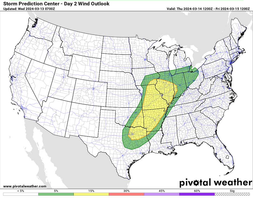
Day 2 Outlook (Thursday).

Day 3 Outlook (Friday).

NWS weather graph data as of 6 am on 13 March 2024.

Note: Wind gusts on Thursday just before noon with a potential for 30 mph winds.
Thursday Outlooks in a bit more detail:

2% Tornado risk to areas in NW Ohio:

5% Hail risk to NW Clinton County and NW Ohio:

5% Risk for Damaging Winds to NW Clinton County and NW Ohio:
Stay Weather Aware!


Comments