2024057 HUM
- Thomas Breckel

- May 5, 2024
- 7 min read
Updated: May 7, 2024
Heads Up Message (HUM)
Update No. 3
Updated: 2 pm on Monday, 6 May 2024
Original Post: 9 am on Sunday, 5 May 20204
*Changes are noted in PINK.
*Key points are noted in YELLOW.
*Recommendations & Resources posted at end of update.
RECOMMENDED THAT ALL CLINTON COUNTY RESIDENTS
REMAIN ESPECIALLY WEATHER AWARE BETWEEN
THE HOURS OF 5 PM AND MIDNIGHT
ON TUESDAY, 7 MAY 2024
Summary:
Tuesday (7 May) - There is a ENHANCED risk (3 out of 5) for severe weather for Clinton County. Two rounds of storms ... the first arriving around or shortly after noon, and the second after 4 pm. The second round will be the one of concern.
Timing: 4 pm to Midnight.
Location: SW Ohio.
15% risk for damaging winds.
15% risk for large hail.
10% risk for significant tornado.
Wednesday (8 May) - SLIGHT risk for severe weather for Clinton County.
Timing: 7 pm to 5 am.
Location: South of I-70.
15% risk for damaging winds.
15% risk for large hail.
2% risk for significant tornado.
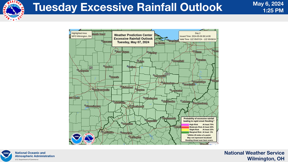
Updated NWS Briefing Slides:
RESOURCES:
Weather Related
NWS ILN Wx Briefing: https://www.weather.gov/media/iln/ILNBriefing.pdf
Clinton County Watches & Warnings: https://alerts.weather.gov/search?zone=OHC027
Thunderstorms: https://www.cc-ema.org/thunderstorm
Tornado: https://www.cc-ema.org/tornado
Alerts & Notifications
Sign-up for Alerts: https://entry.inspironlogistics.com/clinton_oh/wens.cfm
Other Alerts & NOAA Wx Radio Programming: https://www.cc-ema.org/alerts
Emergency Notice Page: https://www.cc-ema.org/notice
Preparation
Prepare Now Page: https://www.cc-ema.org/prepare
Local Hazards: https://www.cc-ema.org/hazards
Energy
Ohio Power Outages: https://poweroutage.us/area/state/ohio
Clinton County Power Outages: https://poweroutage.us/area/county/366
AES Power Outages: https://myprofile.aes-ohio.com/Outages/Outages.html
Duke Power Outages: https://outagemap.duke-energy.com/#/current-outages/ohky
South Central Power Outages: https://outage.southcentralpower.com/
###TBB
- - - - - - - - - - - - END OF THIS UPDATE - - - - - - - - - - - -
Heads Up Message (HUM)
Update No. 4
Updated: 6:30 am on Tuesday, 7 May 2024
Original Post: 9 am on Sunday, 5 May 20204
*Changes are noted in PINK.
*Key points are noted in YELLOW.
*Recommendations & Resources posted at end of update.
RECOMMENDED THAT ALL CLINTON COUNTY RESIDENTS
REMAIN ESPECIALLY WEATHER AWARE BETWEEN
THE HOURS OF 5 PM AND MIDNIGHT
ON TUESDAY, 7 MAY 2024
Summary:
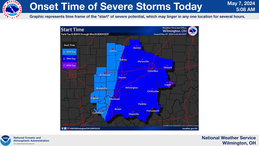
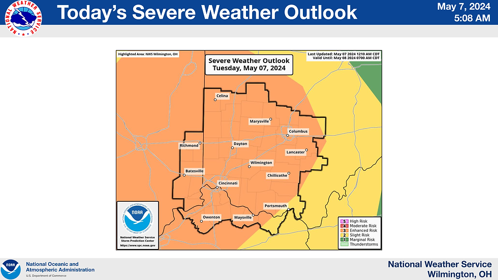
Tuesday (7 May) - There is a ENHANCED risk (3 out of 5) for severe weather for Clinton County. Two rounds of storms ... the first arriving around or shortly after noon, and the second after 4 pm. The second round will be the one of concern.
Timing: 4 pm to 11 pm.
Location: SW Ohio.
15% risk for damaging winds.
15% risk for large hail.
10% risk for significant tornado.
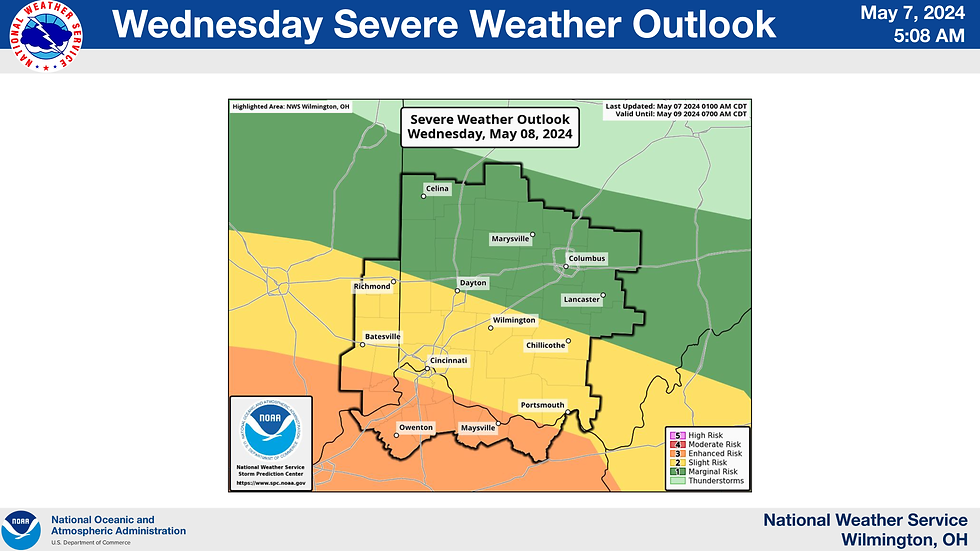
Wednesday (8 May) - SLIGHT risk for severe weather for Clinton County.
Timing: 7 pm to 5 am.
Location: South of I-70.
15% risk for damaging winds.
15% risk for large hail.
2% risk for significant tornado.
Updated NWS Briefing Slides:
Updated SPC DAY 1 (Tuesday) Outlooks:
SPC DAY 2 (Wednesday) Outlooks:
RECOMMENDATIONS:
Visit cc-ema.org/prepare: Make sure to familiarize yourself with crucial keywords such as SEVERE, POWER, and TORNADO at cc-ema.org/prepare.
Document Your Property: Each Spring, take comprehensive photos of your home and property. This documentation is essential for insurance claims in case of damage or loss.
Plan and Communicate: Have a discussion with those you love, like, and tolerate (based on your situation) about emergency procedures, including where to shelter during severe weather events such as tornadoes.
RESOURCES:
Weather Related
NWS ILN Wx Briefing: https://www.weather.gov/media/iln/ILNBriefing.pdf
Clinton County Watches & Warnings: https://alerts.weather.gov/search?zone=OHC027
Thunderstorms: https://www.cc-ema.org/thunderstorm
Tornado: https://www.cc-ema.org/tornado
Alerts & Notifications
Sign-up for Alerts: https://entry.inspironlogistics.com/clinton_oh/wens.cfm
Other Alerts & NOAA Wx Radio Programming: https://www.cc-ema.org/alerts
Emergency Notice Page: https://www.cc-ema.org/notice
Preparation
Prepare Now Page: https://www.cc-ema.org/prepare
Local Hazards: https://www.cc-ema.org/hazards
Energy
Ohio Power Outages: https://poweroutage.us/area/state/ohio
Clinton County Power Outages: https://poweroutage.us/area/county/366
AES Power Outages: https://myprofile.aes-ohio.com/Outages/Outages.html
Duke Power Outages: https://outagemap.duke-energy.com/#/current-outages/ohky
South Central Power Outages: https://outage.southcentralpower.com/
###TBB
- - - - - - - - - - - - END OF THIS UPDATE - - - - - - - - - - - -
Heads Up Message (HUM)
Update No. 3
Updated: 2 pm on Monday, 6 May 2024
Original Post: 9 am on Sunday, 5 May 20204
*Changes are noted in PINK.
*Key points are noted in YELLOW.
Next Update: Estimated for 7 pm on Tuesday, 7 May 2024.
Summary:
Tuesday (7 May) - There is a continued SLIGHT risk (2 out of 5) of severe weather in the afternoon and evening, from 3 pm to 5 pm. The southern part of the county faces a 5% tornado risk, while the northern part has a 10% risk. Clinton County has a 15% chance of hail, and the risk of damaging winds has been reduced from significant to elevated.
Wednesday (8 May) - The southwest part of Clinton County is under a ENHANCED risk (3 out of 5) for severe storms, while the rest of the county has a SLIGHT risk (2 out of 5). Severe weather is expected late Wednesday, from 7 pm to 3 am Thursday. Tornado risks are 10% in the southern third of the county (including Clarksville, Blanchester, Westboro, and Lynchburg) and 5% in the rest. The severe weather risk for Wednesday evening might shift slightly southwest, with a lower risk in west-central and central Ohio.
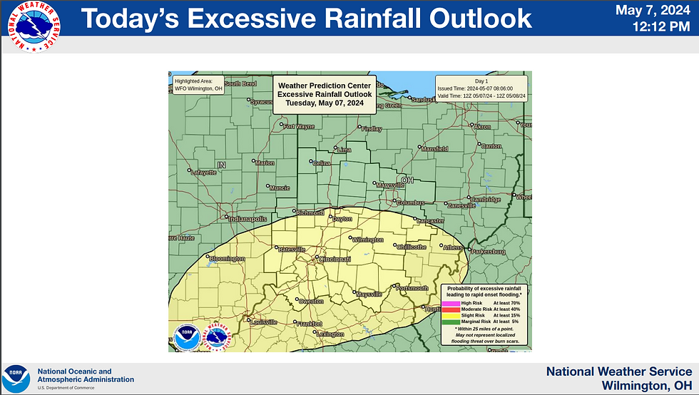
Both days could see large hail, damaging winds, and possible tornadoes. Flooding may lead to high water and road closures.
Updated NWS Briefing Slides:
Dividing line between ENHANCED risk (Clarksville, Blanchester, Westboro, and Lynchburg) in orange and the SLIGHT risk area for the remainder of the county.
###TBB
- - - - - - - - - - - - END OF THIS UPDATE - - - - - - - - - - - -
Heads Up Message (HUM)
Update No. 2
Updated: 6:45 am on Monday, 6 May 2024
Original Post: 9 am on Sunday, 5 May 20204
Summary:
Tuesday (7 May) - SLIGHT risk (2 out of 5) with timing forecasted for the afternoon/evening. Tornado risk 5% of tornado occurring within 25 miles of a given point.
SLIGHT risk includes scattered severe storms possible. Short-lived and or/not widespread, isolated intense storms possible.
Wednesday (8 May) - ENHANCED risk (3 out of 5) with timing forecasted late Wednesday afternoon and into the evening. Too early for official SPC risk assessment for tornado occurrence.
ENHANCED risk includes numerous severe storms possible. More persistent and/or widespread a few intense.
Both days include potential threat for large hail, damaging winds, and a few tornadoes possible. Flooding my lead to high water and road closures.
-- NWS Briefing Slides --
Tuesday Tornado Risk (5%): Link for more information on SPC risk ratings.
*-*- EDUCATIONAL INFORMATION ONLY -*-*
The following is provided for education purposes and is not intended as information for warning & notification. Nadocast is produced via machine learning and is an output that has not been "assessed" by a human. Products generated at approximately 5 am on Monday, 6 May 2024.
The take away from the products below and the forecast above, is that there is a potential for severe weather.
Households should still ensure family members are aware of the potential threats, timing, and places to shelter in the event mother nature decides she wants to go against the forecast and do her own thing 😉
Nadocast output for potential of damaging hail for Tuesday, 6 May 2024:
Nadocast output for Significant Hail for Tuesday, 6 May 2024:
Nadocast output for Significant Tornado risk for Tuesday, 6 May 2024:
Nadocast output for Tornado Day risk for Tuesday, 6 May 2024:
Nadocast output for Significant Wind risk for Tuesday, 6 May 2024:
###TBB
- - - - - - - - - - - - END OF THIS UPDATE - - - - - - - - - - - -
Posted: Sunday, 5 May 20204
The Storm Prediction Center (SPC) has released a DAY 3 forecast for the potential of a SLIGHT risk for severe weather for Clinton County.
SPC DAY 3 Map:
SPC Discussion:
ACUS03 KWNS 050731
SWODY3
SPC AC 050730
Day 3 Convective Outlook
NWS Storm Prediction Center Norman OK
0230 AM CDT Sun May 05 2024
Valid 071200Z - 081200Z
...THERE IS A SLIGHT RISK OF SEVERE THUNDERSTORMS ACROSS PARTS OF
THE MID-SOUTH INTO THE OHIO VALLEY...
...SUMMARY...
Scattered severe thunderstorms appear possible Tuesday from the
Mid-South northeastward into parts of the Ohio Valley.
...Synopsis...
A large, closed upper cyclone over the northern Plains should move little on Tuesday. A lead mid-level shortwave trough with attendant enhanced mid-level jet is forecast to move quickly northeastward across the Upper Midwest and Great Lakes through the day. The southern fringe of this shortwave trough and modest large-scale ascent should overspread parts of the Mid-South into the OH Valley Tuesday afternoon. At the surface, a deep low over ND should slowly occlude, while a weak secondary low develops northeastward in tandem with the shortwave trough across parts of the Upper Midwest and Great Lakes. A moist and unstable airmass should exist along and southeast of a convectively reinforced surface front, generally extending northeastward from the ArkLaTex vicinity into parts of the mid MS and OH Valleys.
...Mid-South into the Ohio Valley...
A line of thunderstorms will probably be ongoing Tuesday morning over parts of AR/MO/IL, associated with convection that developed on Monday across the Plains. This activity may tend to weaken though the morning. But, it could still pose an isolated strong/gusty wind threat. Weak to moderate instability should develop ahead of and to the southwest of these early-day thunderstorms, with greater
instability forecast across the Mid-South and lower OH Valley. Deep-layer shear is forecast to be strong enough to support organized convection, including some supercells. However, with mid-level flow generally aligned with the forecast position of the surface boundary, tendency may be for clusters/bowing line segments to prevail.
Regardless, scattered strong to severe thunderstorms should spread east-northeastward across the OH Valley Tuesday afternoon and evening, posing a threat for mainly damaging winds and severe hail. Across the Mid-South/TN Valley into AR, the severe threat appears more conditional, owing to this region generally being displaced to the south of the better forcing aloft. An isolated threat for severe hail may develop late in the period (early Wednesday morning) across the Ozarks as low-level flow/ascent increases with a strengthening low-level jet.
Given latest model trends and the likelihood for morning convection across the mid MS Valley, it appears that the potential for appreciable destabilization and severe thunderstorms is lower across much of IA, MO, and IL. Have therefore reduced severe probabilities across these areas.
..Gleason.. 05/05/2024
$$
NWS general forecast at this time for Tuesday: A chance of showers before 11am, then a chance of showers and thunderstorms between 11am and 2pm, then showers and possibly a thunderstorm after 2pm. High near 78. South wind 9 to 14 mph. Chance of precipitation is 80%. New rainfall amounts between a tenth and quarter of an inch, except higher amounts possible in thunderstorms.
[END]









Comments