

PNM 20230824
- Thomas Breckel

- Aug 21, 2023
- 4 min read
Updated: Aug 23, 2023
Next update: Unless otherwise stated, the next update will be as soon as critically important or sufficient information becomes available.
Resources:
Cooling Shelters (current list)
Extreme Heat (what to do Before, During, and After)
Power Outage (what to do Before, During, and After)
NWS ILN Wx Briefing Page (auto-update)
Generator Safety (Red Cross)
- - - - - - - - - - - - - -
Update 3: Wednesday, 23 Aug 2023 (4 pm)
Impact Weather Date: Wednesday (23 Aug) thru Friday (25 Aug)
Timing (arrival): Varies (see weather graph at end)
Summary of potential weather pattern this week:
Wednesday: HOT.
Thursday: HOT & STORMY.
Friday: HOT'ish and maybe STORMY for some.
Updated NWS messaging:
Heat will be a concern Wednesday through Friday. The combination of heat and humidity will result in heat headlines through this period.
The most widespread potential for heat is forecast on Thursday. However, shower and thunderstorm potential Wednesday night into Thursday morning may affect that heat potential, particularly across parts of northern and eastern Ohio.
For Wednesday night into Thursday morning, the potential exists for some showers and thunderstorms. The highest probability will be across northern and eastern Ohio. Some strong to severe storms will be possible with damaging winds and large hail the primary threats. In addition, heavy rain and possible training of storms may occur, particularly over northeast Ohio. This may lead to instances of flash flooding. Confidence in specific timing and coverage is low to medium at this time.
Additional showers and storms are forecast for Thursday night. A few strong to severe storms will be possible, mainly north of the Ohio River. Damaging winds and large hail will be the primary threats.
A shower and thunderstorm threat exists along and south of I-70 on Friday. However, coverage is expected to be much less, with isolated instances of a strong or severe storm possible.
Cooler and drier air is expected to move into the region over the weekend, bringing an end to the hot conditions.
Updated slides (notes provided above slide):

(Potential impacts to Clinton County forecasted to be Thursday):


(Excessive Heat Watch in effect for Clinton County on Thursday from Noon to 9 pm):


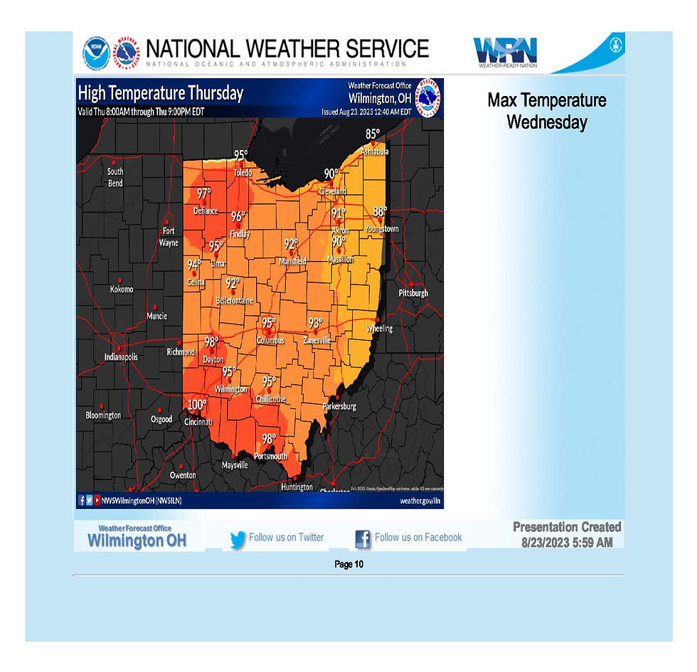
(Heat Index for Clinton County today is forecasted to exceed 100F):


(Heat Index for Clinton County forecast appears lower than Wednesday):


(Potential impacts to Clinton County forecasted to be Thursday):

(Potential impacts south of Clinton County [but could slip our direction] forecasted to be Thursday):


Weather Graph Data:
*Data as of 7 am on Wednesday, 23 August 2023
Wednesday to Thursday:

Thursday to Friday:

Friday to Saturday:

Saturday to Sunday:

[END UPDATE 3]
- - - - - - - - - - - - - -
Update 2: Tuesday, 22 Aug 2023 (4 pm)
Impact Weather Date: Thursday, 24 Aug 2023
Timing (arrival): Afternoon to Evening
Updated NWS messaging:
Heat will be the main weather hazard Wednesday through Friday.
Heat indices approaching 100F for southeastern IN, northern KY, and southwestern OH on Wednesday afternoon and evening.
Highest heat indices areawide on Thursday afternoon and evening between 105 F and 110 F.
Heat indices again excessive near and south of I-70 Friday afternoon and evening.
Cooler and drier air is expected to move into the region over the weekend, bringing an end to the hot conditions.
Confidence in excessive heat potential is high.
Updated slides:


[END UPDATE 2]
- - - - - - - - - - - - - -
Update 1: Tuesday, 22 Aug 2023 (7 am)
Impact Weather Date: Thursday, 24 Aug 2023
Timing (arrival): Afternoon to Evening


NWS weather briefing: https://www.weather.gov/iln/ilnbrf
Updated Messaging:
Heat will be the main weather hazard Thursday into Friday.
The combination of heat and humidity will necessitate the need for heat headlines across the region. The hottest conditions will occur across southeast Indiana, northern Kentucky, and much of Ohio on Thursday. Temperatures will begin to trend downward on Friday. However, locations along and south of Interstate 70 will continue with heat and humidity for one more day.
Cooler and drier air is expected to move into the region over the weekend, brining an end to the hot conditions.
Confidence in heat potential is high.


[END UPDATE 1]
- - - - - - - - - - - - - -
Original Post (21 Aug 2023)
This is your Prepare Now Message for potential heat index of over 100 this Thursday, 24 August 2023 for Clinton County. Current forecast is predicting a heat index of 106.
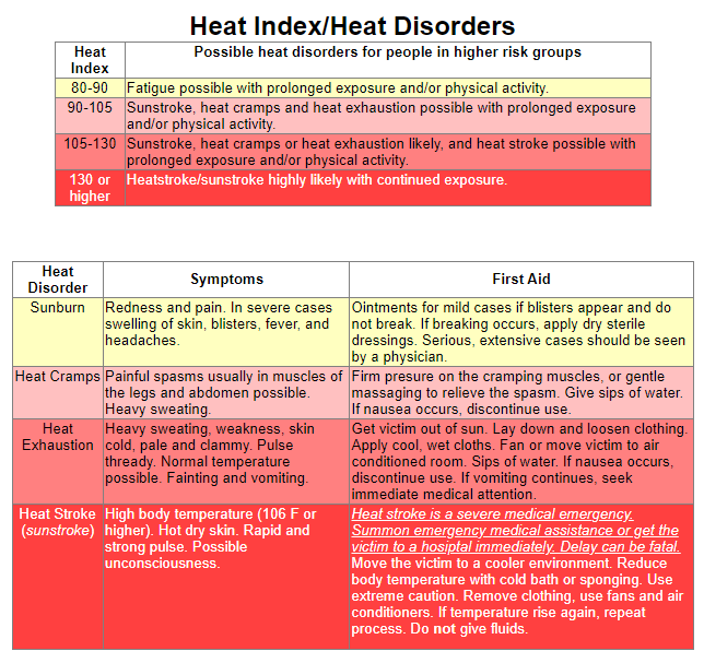
Learn more about Heat Indexes at the National Weather Service.
Safety Tips:
Slow down. Strenuous activities should be reduced, eliminated, or rescheduled to the coolest time of the day. Individuals at risk should stay in the coolest available place, not necessarily indoors.
Dress for summer. Lightweight, light-colored clothing reflects heat and sunlight, and helps your body maintain normal temperatures.
Foods (like proteins) that increase metabolic heat production also increase water loss.
Drink plenty of water or non-alcoholic fluids. Your body needs water to keep cool. Drink plenty of fluids even if you don't feel thirsty.
Do not drink alcoholic beverages.
Spend more time in air-conditioned places. Air conditioning in homes and other buildings markedly reduces danger from the heat. If you cannot afford an air conditioner, spending some time each day (during hot weather) in an air conditioned environment affords some protection.
Don't get too much sun. Sunburn makes the job of heat dissipation that much more difficult.
Cooling Shelters in the event your household has an air-conditioning mishap:

[END]
- - - - - - - - - -
Learn more about how NWS assesses risks for severe weather HERE.
PNM - Prepare Now Message for events with forecasted high severity or impact (e.g. tornado potential, power outage potential, et cetera).
SWA - Stay Weather Aware message for events with the potential of some local impacts (e.g. localized power outage potential, et cetera).
HUM - Heads Up Message for events that are too far off for certainty, but may become significant local threats. Intent is to provide advanced heads up for those with household issues to begin preparing for the potential of impact (e.g. medical, livestock, et cetera).


Comments