

20240402 PNM
- Thomas Breckel

- Mar 28, 2024
- 8 min read
Updated: Apr 2, 2024
Update No. 8 (2:45 pm on Tuesday, 2 April 2024)
Changes: Threat time shifted to 4 pm to 9 pm, with some storms lingering until midnight. Threats continue to be damaging winds, large hail, and strong tornadoes possible.


[END]
- - - - - - - - - - - - - - -
Update 7.5 (12:47 pm on Tuesday, 2 April 2024)
The first cluster of storms is nearing our location, but it will be the second line that will be the most concerning.

Arrival times just before 2 pm for some elements.

[END]
- - - - - - - - - - - - - - -
Update No. 7 (10:30 am on Tuesday, 2 April 2024)
Threats remain the same, but timing shifts for the afternoon:
All Day: Flood Watch in effect thill this evening.
12 Noon to 8 pm: Damaging winds, large hail, several tornadoes (some strong will be possible). Risks for damaging winds and large hail elevated to SIGNIFICANT, and Tornado threat remains SIGNIFICANT. Forecast confidence is medium.
Updated NWS slides:


[END]
- - - - - - - - - - - - - - -
Update No. 6 (6 am on Tuesday, 2 April 2024)
Updated threats for Tuesday:
All Day: Flood Watch in effect thill this evening.
6 am to 11 am: Damaging winds and large hail, a tornado cannot be ruled out. Risks for damaging winds and large hail elevated to SIGNIFICANT.
3 pm to 10 pm: Damaging winds, large hail, several tornadoes (some strong will be possible). Risks for damaging winds and large hail elevated to SIGNIFICANT, and Tornado threat remains SIGNIFICANT.


Slight shift of threat area to the south (still no change for Clinton County).

Adjusted timing for this afternoon.


[END]
- - - - - - - - - - - - - - -
Update No. 5 (5 am on Tuesday, 2 April 2024)
Updated threats for Tuesday:
All Day: Flood Watch in effect thill this evening.
4 am to 8 am: Damaging winds and large hail, isolated tornadoes are possible.
3 pm to 10 pm: Damaging winds, large hail, several tornadoes (some strong will be possible). Tornado threat noted as significant.


Moderate rating (15%-29%):
Threat: A moderate threat to life and property.
Minimum Action: Preparations should be made for a moderate likelihood (or a 15 to 29% probability) of tornadoes; many tornadoes (even families) of F0 to F1 intensity possible.
F0 Tornado Damage - Minor tornado damage; damage to chimneys, a few downed trees and power lines, large signs blown over, damaged porches and screen houses, and damaged lighter-weight outbuildings. Tornado wind speeds of 73 mph or less.
F1 Tornado Damage - Moderate tornado damage; mobile homes moved off foundations or overturned, roof surfaces peeled off buildings, cars blown off roads, several large trees downed and some power outages. Tornado wind speeds of 74 mph to 112 mph.
Potential Impact: The potential for many locations to experience minor to moderate tornado damage (see below). Some tornadoes may have longer damage tracks.
[END]
- - - - - - - - - - - - - - -
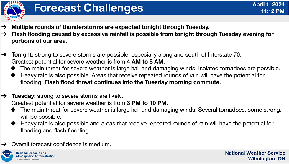
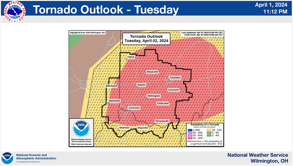
Update No. 4 (5:30 pm on Monday, 1 April 2024)
Significant increase in weather threats for Monday (1 Apr) and Tuesday (2 Apr).
Monday (5 pm Monday to 2 am Tuesday): Damaging winds South of I-70, large hail, and isolated tornadoes possible. Risk rating is 2 out of 5.
Tuesday (3 pm to 10 pm): Damaging winds, large hail, and isolated strong tornadoes. 15% - 29% hatched risk for a tornado occurring within 25 miles of a given point within Clinton County (or the majority of the NWS service area). Risk rating is a 4 out of 5. Take this serious!
Note: Recommend each household have that discussion tonight of How to Get The Alert/Warning, Where To Shelter, and What to Do. Reference keywords SEVERE, TORNADO, and POWER at cc-ema.org/prepare
NWS Graphics:

Monday Threat.

Tuesday Threat.

Tuesday Tornado Threat.

[END]
- - - - - - - - - - - - - - -
Update No. 3 (5:30 am on Monday, 1 April 2024)
No April Fool's joke with this weather, but the current trend shows the threat pushing more down to the Ohio River and into Kentucky. 5% risk for an tornadoes Monday and 2% on Tuesday.


MONDAY focus:
Timing: 6 pm to just after 9 pm.
Risk for severe weather: 2 out of 5
Tornado Risk: 5% chance for the area south of the line drawn between Clarksville to northern Lynchburg. This is defined as a 5% chance of a tornado occurring within 25 miles of a given point within the area of concern.
Hail: 15% risk for 1" or larger hail for Clinton County.
Damaging Winds: 15% chance of damaging winds >50 mph.

Tornado risk of 5% for S/SW Clinton County (the probability of a tornado within 25 miles of a given point in the area of concern).

Hail risk 15% for hail 1" or larger for our county.

Wind risk is 15% for damaging winds (>50 mph).
HRR prediction starting at 5 pm (1700) through 9 pm (2100). What is the HRR?
HRR 5 pm.

HRR 6 pm.

HRR 7 pm.

HRR 8 pm.

HRR 9 pm.

TUESDAY focus:
Risk for severe weather: 2 out of 5
Tornado Risk: 2% countywide. This is defined as a 2% chance of a tornado occurring within 25 miles of a given point within the area of concern.
Hail: 15% risk for 1" or larger hail for Clinton County.
Damaging Winds: 15% chance of damaging winds >50 mph.

Tornado risk 2% for a tornado countywide.

Hail risk 15% for hail 1" or larger for our county.

Wind risk is 15% for damaging winds (>50 mph).

[END]
- - - - - - - - - - - - - - -
Update No. 2 (12 Noon on Sunday, 31 March 2024)
Tracking multiple days of increased risk for severe weather, specifically:
Sunday (31 March 2024) - Marginal risk for severe weather.
Monday (1 April 2024) - MARGINAL risk for northern Clinton County, and 2 SLIGHT RISK for Blanchester and Westboro (and Lynchburg) areas for severe weather. That includes: large hail, damaging winds, heavy rain. 2% tornado risk (F0 to F1 intensity possible).
Tuesday (2 April 2024) - Day of Concern. The northern part of the county will be in a SLIGHT RISK and the southern part will be in an ENHANCED risk for severe weather. That includes: large hail, damaging winds, isolated tornadoes. Tornado risk estimate is not available >48 hours from the forecast day.
Sunday risk graphic (1 out of 5 on the risk scale). Occasional showers and thunderstorms will be possible today into tonight. A few strong to severe storms will be possible late this afternoon and evening with large hail the main threat.

Monday risk graphic (1 & 2 out of 5). Multiple rounds of showers and thunderstorms are expected Monday through Tuesday. Repeated rainfall could lead to flooding concerns, and there is also a chance for some severe storms. Large hail and damaging winds would be the main severe threat although an isolated tornado will also be possible.

Tuesday risk graphic (2 & 3 out of 5). This is the day to be concerned with! Multiple rounds of showers and thunderstorms are expected Monday through Tuesday. Repeated rainfall could lead to flooding concerns, and there is also a chance for some severe storms. Large hail and damaging winds would be the main severe threat although an isolated tornado will also be possible.

Current recommendations:
Visit cc-ema.org/prepare: Make sure to familiarize yourself with crucial keywords such as SEVERE, POWER, and TORNADO at cc-ema.org/prepare.
Document Your Property: Each Spring, take comprehensive photos of your home and property. This documentation is essential for insurance claims in case of damage or loss.
Plan and Communicate: Have a discussion with those you love, like, and tolerate (based on your situation) about emergency procedures, including where to shelter during severe weather events such as tornadoes.
Additional Information:
By a large majority, F0 & F1 tornadoes occur more often than F2 to F5 tornadoes.
F0 Tornado Damage - Minor tornado damage; damage to chimneys, a few downed trees and power lines, large signs blown over, damaged porches and screen houses, and damaged lighter-weight outbuildings. Tornado wind speeds of 73 mph or less.
F1 Tornado Damage - Moderate tornado damage; mobile homes moved off foundations or overturned, roof surfaces peeled off buildings, cars blown off roads, several large trees downed and some power outages. Tornado wind speeds of 74 mph to 112 mph.
F2 to F5 Tornado Damage - Major tornado damage (up to complete destruction); mobile homes completely demolished, numerous large trees snapped off or totally uprooted, small debris objects (lawn mowers, smaller sections of roofs) become airborne missiles. Increasingly larger areas of power outages. Structural damage to sturdy buildings becomes a concern, beginning with roof and wall failures. In the worst situations, well-constructed walls fail or are even removed. Large debris objects (cars, larger sections of roofs) become airborne missiles causing further structural failures. Trees debarked. Tornado wind speeds 113 mph or greater, but in worse case situations 260 mph or greater.
[END]
- - - - - - - - - - - - - - -
Update No. 1 (10 am on Friday, 29 March 2024)
Tracking potential for MARGINAL risk of severe weather on Sunday (31 March 2024) and the potential for stronger storms on Tuesday (2 April 2024).
Hazardous Outlook for Sunday: There is also a MARGINAL risk for severe thunderstorms Sunday afternoon and evening. Additional severe thunderstorms are possible on Tuesday. Large hail and damaging wind are expected to be the main
hazards both Sunday and Tuesday.
ILN Weather for Sunday: A chance of showers and thunderstorms before 2pm, then showers likely between 2pm and 5pm, then showers likely and possibly a thunderstorm after 5pm. Mostly cloudy, with a high near 66. Northeast wind around 8 mph becoming southeast in the afternoon. Chance of precipitation is 60%. New rainfall amounts of less than a tenth of an inch, except higher amounts possible in thunderstorms.


[END]
- - - - - - - - - - - - - - -
Original post: Thursday, 28 March 2024
This is your Prepare Now Message (PNM) for Tuesday, 2 April 2024 for the potential of severe weather (i.e., damaging winds and possible tornado).
The Storm Prediction Center (SPC) has issued a Day 6 Probabilistic outlook for severe weather for Tuesday, 2 April 2024.

The SPC discussion identified as of 28 March the following:
...Day 6/Tuesday: Ohio/Tennessee Valleys into the Appalachians...
Some severe threat should continue Tuesday over parts of the OH/TN Valleys into the Appalachians as the upper trough continues eastward. Even though there is still some uncertainty with the exact placement of the primary surface low and evolution of the upper trough, enough confidence exists in a fairly narrow corridor across these regions to add a 15% severe area for Tuesday. Rich low-level moisture should be in place ahead of an eastward-moving cold front. Redevelopment and/or re-intensification of convection seems probable by Tuesday afternoon. Strong deep-layer shear and weak instability should be sufficient for organized severe convection posing some threat for damaging winds, and perhaps tornadoes given the forecast strength of a low-level jet focused over parts of the OH/TN Valleys. The northward extent of the severe risk across OH and vicinity remains uncertain, as the placement of the warm front varies in model guidance. Similarly, convection should eventually encounter a less unstable airmass across the Appalachians. But, an isolated severe risk may continue Tuesday evening into early Wednesday morning across the southern/central Appalachians into portions of the Southeast.
Current recommendations:
Visit cc-ema.org/prepare: Make sure to familiarize yourself with crucial keywords such as SEVERE, POWER, and TORNADO at cc-ema.org/prepare.
Document Your Property: Each Spring, take comprehensive photos of your home and property. This documentation is essential for insurance claims in case of damage or loss.
Plan and Communicate: Have a discussion with those you love, like, and tolerate about emergency procedures, including where to shelter during severe weather events such as tornadoes.
As we enter the Spring season, while the weather may seem mild at present, it's crucial to be prepared for unexpected changes. From everyone at Clinton County EMA, we wish you safety and well-being. Stay informed, stay safe! 😊
Special thanks to Ethan Emery for drawing my attention to this forecasted threat 👍


Comments