

AL91 (GABRIELLE)
- Thomas Breckel

- Sep 5, 2025
- 5 min read
Updated: Sep 8, 2025
Update: AL91 was looking like it might grow into Tropical Storm Gabrielle, but the system ran into problems that stopped it from developing. A big pocket of dry, dusty air moved in from the Sahara Desert and mixed into the storm, cutting off the warm, moist air it needed to grow. At the same time, winds high in the atmosphere shifted directions and created wind shear, which tore apart the thunderstorms trying to organize. Without steady fuel and structure, the storm quickly lost strength and faded out before it could become a named system.
- - - - - - - - - - - -
AL91 (likely to be named Gabrielle) — What We Know, What’s Next, and Why SW Ohio Should Watch
Posted: 7:30 am on 5 September 2025.
Summary
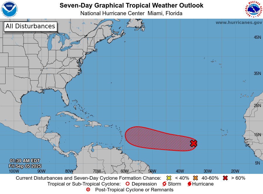
A broad low (AL91) near 13°N/35°W in the eastern tropical Atlantic continues to organize while drifting west. Environmental conditions are favorable, and the National Hurricane Center puts formation odds at 60% in 48 hours and 90% within 7 days. Guidance places the disturbance near the Lesser Antilles by the middle to latter part of next week. No U.S. threat is identified at this time.
Weather Action Level Scale
Awareness 👈 Clinton County is here
Meaning: Weather patterns are being tracked, but no direct threat at this time.
Reader’s Signal: Stay generally aware; check reliable sources for updates.
Review
Meaning: Potential exists for a weather threat. Time to revisit household, school, and workplace plans or policies.
Reader’s Signal: Review where to go, how to get alerts, and what supplies you have on hand.
Be Ready
Meaning: A significant threat is possible. Conditions are favorable for hazardous weather.
Reader’s Signal: Secure outdoor items, verify alerts, and prepare to act quickly.
Monitor
Meaning: The threat is likely and conditions are approaching critical thresholds. Key decisions (school closings, event cancellations, sheltering) may soon be required.
Reader’s Signal: Stay alert for warnings and be watchful for the moment when it’s necessary to move from readiness into action.
Take Action
Meaning: Weather threat is imminent or occurring.
Reader’s Signal: Move immediately to safety and follow official warnings without delay.
Outlook & Track Thoughts
AL91 is still a developing disturbance, so track and intensity confidence is low. The

current NHC discussion emphasizes gradual development with a slow westward motion (about 5–10 mph) and a position in the vicinity of the Lesser Antilles mid- to late next week. Whether it later curves north into the open Atlantic or holds a more southern route into the Caribbean will hinge on how quickly it organizes and the strength/placement of the subtropical ridge.
Timing — Earliest & Most-Likely Windows to the Gulf of America
These windows are scenario ranges, not a forecast, and assume a southern track

through the Caribbean. They’ll tighten if/when AL91 becomes a numbered system.
Earliest plausible Gulf entry: Sept 15–17 (Sun–Tue) — requires steady organization, forward speed trending toward the higher end of guidance, and minimal disruptions crossing the Lesser Antilles/Eastern Caribbean. (Low confidence.) Derived from current position near 35W and NHC language placing it near the Lesser Antilles by mid–late next week.
Most likely window: Sept 17–20 (Wed–Sat) — consistent with a slower, more typical pace from the eastern Atlantic to the eastern Caribbean and onward toward the western Caribbean/Gulf, per the NHC outlook timing. (Low–moderate confidence.)
If AL91 remains disorganized or encounters shear/dry air, entry could slip later into the following week (after Sept 20). (Low confidence; timing will depend on actual development.)
Why This Matters in Southwest Ohio
Even distant tropical systems can affect us days after landfall via high winds, power outages, and heavy rain. Two recent Ohio Valley examples:

Hurricane Ike (2008): Ike made Texas landfall near the north end of Galveston Island at 0700 UTC Sept 13 (2:00 a.m. CDT). By Sept 14 (Sun), the remnants drove hurricane-force wind gusts across parts of the Ohio Valley, including SW Ohio — roughly ~36 hours after Texas landfall. This is a useful mental timeline for inland wind impacts when a large, fast-moving system recurves toward the Ohio Valley.
Hurricane Helene (2024): Remnants on Sept 27, 2024 brought 60+ mph gusts, flooding, and widespread outages in the southern Ohio Valley and surrounding states.
What to Watch Next
Designation/Advisories: If AL91 becomes a depression/storm (“Gabrielle”), official forecast tracks and timing cones begin — that’s when confidence improves. Check the NHC Outlook and Tropical Weather Discussion updates.
Approach to the Lesser Antilles: Mid–late next week is the key checkpoint for speed/track clues.
Pattern drivers: Subtropical ridge strength and any trough over the U.S. East will steer whether a Caribbean/Gulf route remains viable (to be assessed once advisories start).
Preparedness Notes
Even though we’re far from the coast, the remnants of past hurricanes — like Hurricane Ike in 2008 — left parts of Clinton County without power for multiple weeks. Preparing now reduces the stress and hardship if outages occur again.
Review how you’d secure loose outdoor items and critical documents if a damaging-wind event were to be forecast here.
Ensure you have multiple ways to get alerts (including CCEA), battery/backup power for phones, and a basic outage kit (flashlights, batteries, meds, chargers).
Review your preparedness plan for extended power outages:
Have a plan to ensure phones, laptops, and power banks can be fully charged in advance.
Review your stock of extra batteries for flashlights, weather radios, and medical devices.
If you rely on a generator, confirm it’s operational, store fuel safely, and review proper ventilation practices. This would also be a great time to service your generator (e.g., oil change, check spark plug, etc.).
Check that you have enough shelf-stable food and bottled water (minimum 1 gallon per person per day for several days).
Plan for special needs — refrigerated medications, oxygen, or medical equipment requiring power.
For organizations: confirm your severe-weather comms tree, check backup power systems, and review generator safety steps now; don’t wait for a watch/warning.
Bottom line: AL91 is likely to become Gabrielle within a few days and reach the Lesser Antilles mid–late next week. A Gulf of America scenario would not be before the Sept 15–17 earliest window, with Sept 17–20 the more realistic range if it stays on a southern track — still low confidence today. SW Ohio should monitor; history (Ike, Helene) shows inland wind and power impacts can arrive within ~1–2 days of a U.S. landfalling system accelerating toward the Ohio Valley. As always, Mother Nature reserves the right to do whatever she decides to do — which may be something entirely different.
[END]


Comments