

Potential for Severe Wx 20250515-16
- Thomas Breckel

- May 15, 2025
- 5 min read
Updated: May 16, 2025
Update No. 3: posted 2 pm on 16 May 2025.
Changes for Clinton County based on the 12:40 pm NWS ILN Weather Briefing from the 5 am version, and discussions during the 1:30 pm NWS Weather Telecon:
Window for highest probability of weather impact is between 6 pm and Midnight tonight (Friday). Peak time is between 8:40 pm and 9 pm (see graphic below).
Tornado risk still noted as SIGNIFICANT, however the area has expanded to Area Wide. Highest threat along the Ohio River areas.
Confidence for a few Tornadoes remains high, but lower for strong/violent (EF-2 to EF-5) tornadoes.
Damaging Wind Gusts still noted as potentially >75 mph, but now widespread.
Large Hail now referenced as potentially >2 inches, however, confidence has decreased from High to Medium-to-High (slight change). Highest risk time 8 pm to 10 pm.
Flooding remains LIMITED, but will still likely impact planting efforts in the county. A faster moving storm may help limit the overall flood threat.

As always, stay weather aware!
[END of Update No. 3]
- - - - - - - - - - - - - - - - - - - -
Update No. 2: posted 10:50 am on 16 May 2025 - NWS weather briefing to be conducted at 1:30 pm. More information to follow.
- - - - - - - - - - - - - - - - - - - -
Update No. 1: 6:30 am on 16 May 2025.
Friday brings a higher chance of strong storms for our county. Here’s what to expect:
Severe Thunderstorms (ENHANCED risk) - Many storms could become severe across Clinton County.
Tornadoes
Southern portion of Clinton County (ENHANCED risk) around Clarksville, Blanchester, Westboro, Midland, the “West LA” (Lynchburg) area, Martinsville, and New Vienna, a 10–15% chance of a tornado within 25 miles. This area is “hatched,” meaning if there is a tornado that there’s a 10% chance of it being EF-2 to EF-5.
Rest of the county (SLIGHT risk): a 5–10% chance of a tornado within 25 miles.
Wind (ENHANCED risk)A 30–45% chance of wind gusts over 58 mph within 25 miles. Expect downed branches and possible power outages.
Hail (SLIGHT risk)A 15–30% chance of hail at least 1 inch across the county.
Lightning (ELEVATED risk)Numerous storms with dangerous cloud-to-ground lightning.
Power Outages
If your home is in the Southern portion of Clinton County (described above) and your neighborhood is prone to storm-related outages, your probability of losing power is Likely – 70–89%.
Elsewhere in the county, your probability of losing power is Unlikely – 30–49%.

Note: When an afternoon rainstorm lingers and keeps thick clouds overhead, it strengthens the atmospheric “cap” (convective inhibition), which suppresses evening storms. But if the sun breaks through and the cap erodes, surface heating boosts instability and allows stronger storms—and a higher tornado risk—to develop.
[END of Update No. 1]
- - - ORIGINAL POST - - -
Severe Weather Threat for May 15–16, 2025: What You Need to Know

Residents across the Wilmington, Ohio area should prepare for two separate rounds of storms—one Thursday evening into the early overnight hours, and a second, more widespread and dangerous round Friday evening through early Saturday morning. These storms could bring severe weather threats, including tornadoes, damaging winds, large hail, and flash flooding.

Round One: Thursday Evening into Early Friday
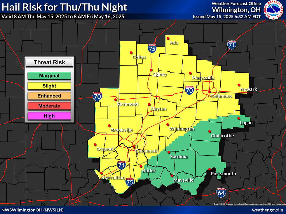
Storms will begin developing this evening, mainly north of the I-70 corridor. While there is still some uncertainty about how far south storms may reach, a few could dip into central Ohio. The threats from these storms include:
Tornadoes (Low Risk): A few isolated tornadoes are possible, especially if the storms stay more scattered and don’t form into a solid line.
Damaging Winds (Elevated Risk): Some storms may produce strong winds capable of knocking down trees and powerlines.
Large Hail (Elevated Risk): A few storms could produce hail large enough to damage vehicles, roofs, or outdoor items.
These threats are expected mainly between 8 PM Thursday and 2 AM Friday.
Round Two: Friday Evening through Early Saturday
This round is expected to be more intense and widespread. It will likely impact areas south of I-70, including south-central Ohio and the Tri-State region (where Ohio, Kentucky, and Indiana meet). Storms may start out as individual supercells and then form into a larger, more dangerous line overnight.
Tornadoes (Elevated Risk): A few tornadoes are possible Friday evening, including the risk for stronger tornadoes.
Damaging Winds (Significant Risk): Widespread damaging winds are expected, strong enough to bring down numerous trees and powerlines. Some areas could see structural damage.
Large Hail (Elevated Risk): Storms may produce hail large enough to cause damage.
Flash Flooding (Elevated Risk): Heavy rainfall falling on already saturated ground could lead to localized flooding in low-lying or poor-drainage areas.
Timing for this second round is 6 PM Friday through 2 AM Saturday.
What You Should Do
Stay Informed: Monitor Clinton County Emergency Alerts (CCEA), local weather updates, and the NWS Wilmington feed for real-time warnings.
Have a Plan: Know where your safe shelter area is—especially if you live in a mobile home or are traveling.
Prepare for Power Outages: Strong winds could knock out electricity. Charge your devices and have flashlights ready.
Avoid Flooded Roads: If water covers the road, do not try to drive through it. “Turn Around, Don’t Drown.”
Both rounds of storms could bring quick changes in weather, so having multiple ways to receive alerts is key. The next NWS update is expected by 6 PM Thursday (briefing located here 👉https://www.weather.gov/media/iln/ILNBriefing.pdf).
Reference keywords SEVERE, POWER, and TORNADO at https://www.cc-ema.org/prepare.
Resources for More Information
Clinton County EMA provides several preparedness resources online to help residents prepare for severe weather. The following blog posts offer additional guidance:
- - - - - - Graphical Hazardous Weather Outlooks - - - - - -
(as of 6:50 am on 15 May 2025)
Thursday, 15 May:


Friday, 16 May:


[END]


Comments